100 Florida Trails®
Top FL Multi-use Bike Trails
Map Links & Photos Galore
Coast-to-Coast Updates
You are here >
Home >
Trails >
South FL-East >
Lake Okeechobee Scenic Trail
Latest update: February 2026
Lake Okeechobee Scenic Trail (LOST)... South Florida
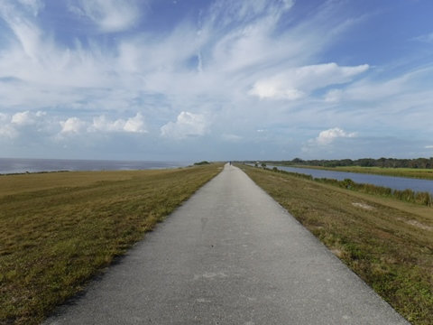
110 Mile Bike Trail Circles Lake atop a 35-Foot High Dike
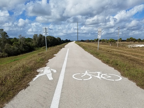
Trail users here are completely exposed to the elements, so weather is key. Lake Okeechobee is the second largest freshwater lake in the USA. The "Scenic Trail" circles the lake atop the 35-foot high Herbert Hoover Dike, now about 75% paved. For most bikers, we recommend the paved sections only, due to many flat tires reported on the unpaved sections (spurs galore). For hikers, the trail also forms a loop in the Florida National Scenic Trail. Below, we divide the trail into 4 sections to better help you find the best biking.
Trail Map Overlay... Lake Okeechobee Scenic Trail
View Larger Map
Location: Glades, Hendry, Martin, Okeechobee, and
Palm Beach Counties
Mileage: About 110 miles (83 mi.
paved, 24 mi. gravel, 3 mi. roadside, plus detours around
locks, *all mileage approximate)
Nearby Cities: Okeechobee, Pahokee, Belle Glade, Clewiston, Moore Haven
Nearby points of interest:
Lakeside Ranch STA, 2700
acre wetlands project, limited hours, biking, hiking
Bike Shops/Rentals: N/A
Page Summary:
Lake Okeechobee Scenic Trail (LOST) - An Overview in 4 Sections
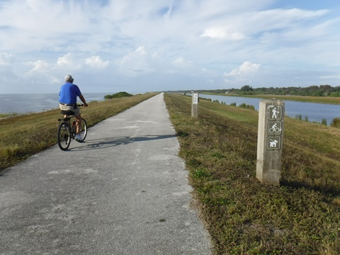
We describe the trail in 4 sections, starting from the Kissimmee River in the north and proceeding clockwise around the entire lake. Note: There is no official LOST starting point, or "mile 0." A few large mile markers (MP#) painted on the trail indicate distances from South Bay, used by the U.S. Army Corps of Engineers for logistical purposes. For the most part, trail access is restricted to canal crossings. We have done our best to note all parking access options with a "P" on our map overlay (above). Follow the links in the trail sections below for detailed full-page reports with photos galore.
Northeast Side - 27 miles - Kissimmee River to Port Mayaca (north)
This section of LOST runs from the east side of the Kissimmee River near Okeechobee to the detour around the lock at Port Mayaca.
- The trail here is paved, running mostly along the shore of Lake Okeechobee with good lake views. On the canal side, trailer parks and other development can be seen, along with agricultural fields.
- Trail access is blocked at Taylor Creek, the trail is along the road to Nubbin Slough access, about 2.5 miles. At Port Mayaca, the trail detours onto the road around the lock. Then unpaved
- Trailheads with restrooms are at the Okee-Tantie Recreation Area and Cliff J. Betts Recreation Area at Okeechobee.
- We recommend 2 sections for recreational bikers: 7 miles from the Kissimmee River to Taylor Creek, and 18 miles from Taylor Creek to Port Mayaka. (Note: These are not continuous due to the detour at Taylor Creek.)
Southeast Side - 25 miles - Port Mayaca (south) to South Bay
This section of LOST starts from the south side of the lock at Port Mayaca and runs south to the South Bay Access.
- The trail is unpaved from Port Mayaca to Pahokee, then becomes paved continuing to South Bay.
- The trail runs lakeside with good lake views, and across the canal mostly sugar cane or cattle.
- Trailheads with restrooms are at Pahokee, Paul Rardin Park and South Bay.
- We recommend the 8 miles from Pahokee to Paul Rardin Park for casual recreational bikers.
Southwest Side - 28 miles - South Bay to Moore Haven
This section of LOST extends from the South Bay access to Alvin Moore Park east of the lock at Moore Haven.
- The trail here is paved.
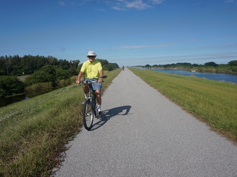
- From South Bay to Clewiston the trail parallels US 27, with the lake to the north and mostly sugar cane fields to the south (except at the towns). Past Clewiston the trail leaves the lakeside, with marsh views.
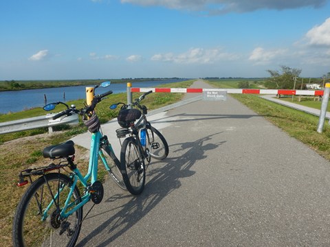
- The trail detours onto the roadway around the locks at Clewiston and Moore Haven
- Trailheads with restrooms are at South Bay, John Stretch Park, Clewiston, Uncle Joe's Fish Camp/Liberty Point, and Moore Haven.
- We recommend the 14 miles from Clewiston to Moore Haven for recreational bikers.
Northwest Side - 31 miles - Moore Haven to Okeechobee
This section runs from the west side of the lock at Moore Haven back to Okeechobee at the Kissimmee River.
- The trail is paved from Moore Haven to Harney Pond Canal Recreation Area, and then unpaved to the Kissimmee River. This section is not lakeside but through marshlands.
- Restrooms are available at the Harney Pond Canal Recreation Area.
Lake Okeechobee Scenic Trail (LOST)... Additional Tips & Suggestions
- The surface consists of both paved and gravel hardpack portions. The gravel sections are better for mountain bikes or hiking.
- The trail is not always continuous, with short diversions onto roadways to go around locks.
- While there are numerous access points with parking (mostly at boat ramps), only a few have restrooms - you can go long distances before finding a restroom.
- Food or convenience stores are accessible from some access points.
- Bring water, snacks, and sunscreen, there is no shade - better as a cool weather ride.
- It can get very windy on the dike. Watch the weather and get off the dike to avoid lightning strikes.
- There are 14 camping areas on or adjacent to the trail - four fee campgrounds provide toilets and showers, primitive campsites have no facilities.
About Lake Okeechobee and the Herbert Hoover Dike
- Lake Okeechobee is the second largest freshwater lake wholly contained within the 48 contiguous United States (Lake Michigan is larger), covering 730 square miles with a relatively shallow average depth of 9 feet. The name is from the Seminole words “oki” and “chubi” meaning "big water.” Originally, water from the lake flowed naturally into The Everglades but as the area developed was diverted into canals. In recent years, environmental concerns have increased including algae blooms on the lake and polluted waters released to the St. Lucie and Caloosahatchee Estuaries. It's a complicated issue, involving protecting the integrity of the dike, feeding The Everglades, and protecting the fragile coastal estuaries, with farming interests also on the table. Learn more about the Lake Okeechobee Watershed Restoration Project
- The Herbert Hoover Dike completely surrounds Lake Okeechobee, built in the 1930s after the destruction and loss of life from hurricanes in the late 1920's, and expanded after more storms and flooding in the late 1940's. In the 1990's and early 2000's, wear and erosion issues were identified and an ongoing, 18-year rehabilitation program was completed in 2023. The 35-foot tall dike was built and is maintained by the U.S. Army Corps of Engineers. Learn more about the Herbert Hoover Dike
More Information and Resources
Nearby Biking:
Southeast FL Region - More trails plus Regional Overview map
Nearby Paddling:
Related Resources:
Find Trails by FL Region or Listed A - Z

100FloridaTrails.com... 100+ Florida Multi-use Bike Trails, Best for Safe, Fun Recreation and Fitness
Other Websites:
BikeOrlando.net
PaddleFlorida.net
BikeTripper.net
Copyright © 100FloridaTrails.com. All Rights Reserved.